|
GPNDG
Great Pacific Northwest Dryside Gather ™ |

|
July 23-26, 2015
White Bird, ID
N 45° 44.591' — W 116° 19.525'
[ For Google use: +45 44' 36.47", -116 19' 32.40" ]
| Site • Crew • Maps • Register • Activities • Rules • Who's Signed Up? • Rides |
Interesting Day Rides
Pittsburg Landing, Snake River, Hells Canyon [~34m]
A 17-mile ride from the campsite over the Pittsburg Saddle (4,300') and down into Hells Canyon ending at the Snake River. This is a gravel road (the first 3 miles are paved) with some serious switchbacks on the Hells Canyon side. The spectacular vistas of Hells Canyon make this 45 minute ride very worthwhile. Easily done even on a Gold Wing, but don't try it if you aren't comfortable on gravel, because the switchbacks are blind, steep and sharp, and had a 2" layer of loose gravel on them in September of 2011.
Elk City, ID [~140m]
I highly suggest this ride — it's fairly short (maybe 3 hours of saddle time) and the last half along the river is perhaps more scenic and twisty than the Lolo Pass highway. I documented a ride on this road a dozen years ago. There is food and fuel available in Elk City, but if you fuel up in Grangeville and can do 100+ miles on a tank you should be good to go. Red River Hot Springs is about 25 miles east of Elk City (though it is I believe a gravel road), so you could probably enjoy a good hot soaking in the middle of the ride if that was of interest.
McCall, ID [~150m]
A nice 75 mile one-way ride south on US-95 with lots of twisties and some nice scenic vistas. Follows the Salmon River upstream, and then up several tributaries to the town of New Meadows, where you turn left (east) on ID-55 for the final 9 mile section. There is a very twisty bit some will love climbing to about 5,400' before dropping into the pretty little town of McCall. A great lunch ride, which you could combine with a swim in Payette Lake and/or some sun bathing on the beach just 1/2 block from downtown.
Lolo Pass, ID/MT [~310m]
A longer day ride would be to do the famous Lolo Pass via ID-13 from Grangeville to US-12 at Kooskia (pronounced "KOOS-key"). Fuel up at Kooskia. There wasn't fuel at Lolo Hot Springs (the turn-around point) the last time I was there, but there was fuel at the Lochsa Lodge, (say "LOCK-saw") south off the highway just west of the Lolo Pass summit. Or you can do another 25 miles or so and ride to good fuel at Lolo, MT, on US-93.
There is a restaurant at the hot springs. If you haven't ridden this famous motorcycle road, this is the ideal time to do it. Total time in the saddle should be just 6 hours or so, and you get to miss the less interesting, and heavier traffic of, the lower part of US-12 from Kooskia to Lewiston. US-12 is fairly well patrolled, so take care with speed management and watch your six!
Another option would be to shorten the ride by stopping at Jerry Johnson Hot Springs, about 1/2 up the Lolo Pass highway on the river side. It should be marked with at least "Jerry Johnson" and you should see a foot/horse bridge across the Lochsa River. The hike to the springs is about a mile from US-12 (after crossing the bridge).
From the Internet:
"The first spring is the HOT one. This one literally gushes out of the side of hill and flows down about 20 feet into Warm Spring Creek. Before dumping into the chilly creek, the hot water pools in a couple of "hot tubs" made with walls of small rocks. So, if conditions are right, you can have your pick of several pools to take a dip into. These pools are right next to the creek (when the creek is high, these pools can sometimes be submerged offering nowhere to enjoy the warmness.
The next set of hot springs is a little hike further (a few hundred feet. These springs come right up from the ground a little further away from the creek. These pools aren't quite as warm, but they are further away from the creek and are fairly protected. There are several sources of hot water here, so you might be able to gain more privacy here."
I (Da Boss) have personally visited this hot springs, and give it two thumbs-up!
Wallowa Mountain Loop, ID/OR/WA [~400m]
This 10 hour ride covers some serious twisties: US-95 down to Cambridge, ID-71 to Oxbow Dam on the Snake River, Oxbow, OR then OR-86 SE to NFD-39 and over the mountains to Joseph, OR. Then up to Enterprise, and WA-3 up the Rattlesnake Grade to Lewiston, then back to the campsite. An ambitious and tiring day, but you'll definitely get your fill of twisty roads, and beautiful scenery. All paved roads, though a bit of it may be rough pavement, and there is always the potential for in-progress road construction.
Do take the narrow paved side road to the "Hells Canyon Scenic Overlook" near the summit on NFD-39 (about half way between "B" and "C" on the map above). It's about the best view of Hells Canyon you can get from a paved road.
There's another Hells Canyon overlook, just a little turn-out, on OR-3 north of Enterprise when you get up to elevation in the trees. It's worth a look too if only because you ride right by it.
Between Cambridge, ID and Joseph, OR there is no fuel. There may be a cafe in Oxbow (there was a new place several years ago), but with the economy, don't count on it. Lots of restaurants in Joseph and Enterprise — I recommend La Laguna Mexican restaurant, there's one in both Joseph and Enterprise (same owner). They have a dish called something like "Pollo Sinestra" which is chicken in a mustard sauce (their original recipe) which is both unusual and very tasty!
Phil's Off-Pavement Rides
This area is well known for ATV trails, and ATVs are very popular hereabouts. If you have ATV(s) you might consider bringing them. If nothing else, they are a safer way to get back from the Silver Dollar Bar at 2am than riding a bike.
Phil has done these 4 rides on a KLR and found them enjoyable. Here are the GPS tracks in two formats so you can either create a Google map, or load them into your own GPS.
GDB format(180kb)
GPX format (1.2mb)
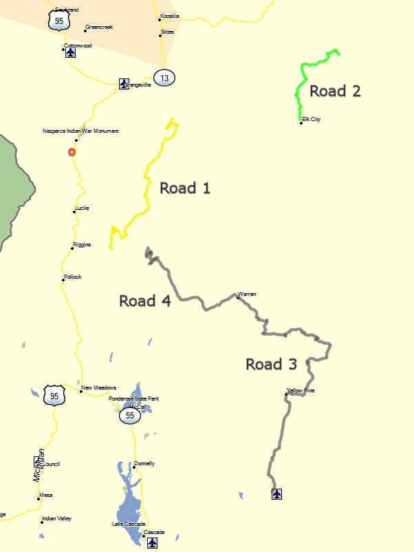
Note that The Gather campsite is approximately where the red circle is just south of the Nesperce Indian War Monument. And here are the elevation profiles and distances of the various rides.
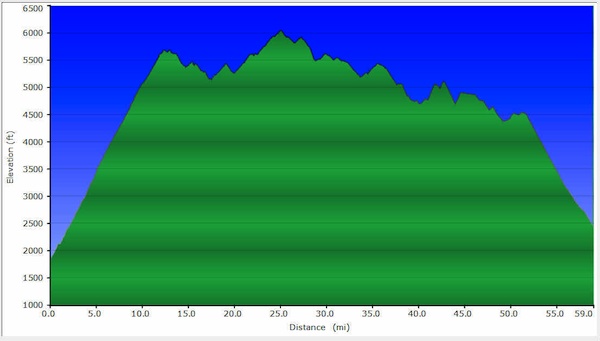
Road #1
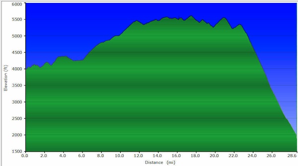
Road #2
The last part of Road #2 is actually a very steep ATV trail, descending to the Selway River. He pretty much used up his brakes on the way down, and isn't sure he'd want to ride UP it on a KLR. Once at the Selway, you can take another gravel road to Lowell (on paved US-12), where the Lochsa and Selway rivers join to form the Clearwater, which empties into the Snake river between Clarkston, WA and Lewiston, ID.
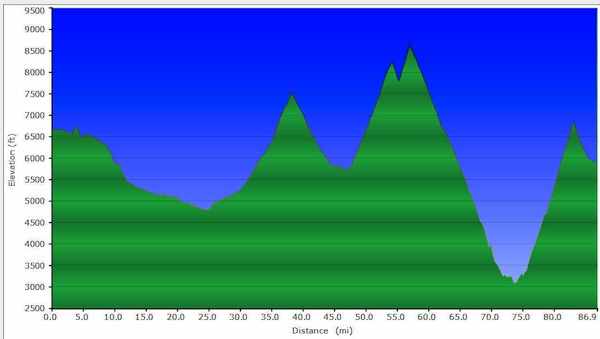
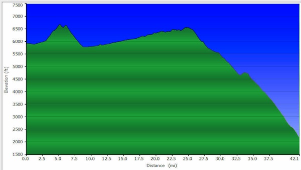
Road #3
Notice that Road #3 reaches an altitude of 8,700' — it's a safe bet that it's way cooler up there! Plus that, Phil says that the town of Warren (joining Road #3 and Road #4) has a cafe.
Road #4