|
GPNDG
Great Pacific Northwest Dryside Gather ™ |

|
July 23-26, 2015
White Bird, ID
N 45° 44.591' — W 116° 19.525'
[ For Google use: +45 44' 36.47", -116 19' 32.40" ]
| Site • Crew • Maps • Register • Activities • Rules • Who's Signed Up? • Rides |
Map to the 21st GPNDG
Distances from various places
| Miles | Time | From |
|---|---|---|
| 90 | 1:45 | Lewiston, ID |
| 200 | 3:45 | Spokane Valley, WA |
| 400 | 7:10 | Seattle, WA |
| 425 | 7:40 | Portland, OR |
| 555 | 11:15 | Calgary, AB |
| 580 | 10:45 | Reno, NV |
| 800 | 14:30 | San Francisco, CA |
| 830 | 15:00 | San Jose, CA |
| 940 | 15:45 | Ft. Collins, CO |
| 1,060 | 19:00 | Escondido, CA |
| 2,130 | 35:00 | Columbus, OH |
| 2,690 | 44:00 | Gainesville, FL |
Visual Aids to Finding the Campsite

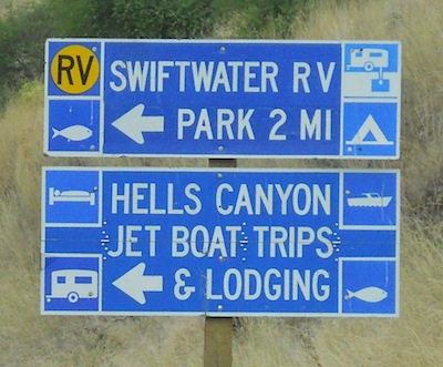
Coming from the north, from Grangeville, just south of White Bird look for Hoots Cafe/Motel on the left. You want the next right after that. The signs are shown in the photo above. The small blue one says SWIFTWATER RV, and at the far left edge of the photo you can see the intersection sign. Turn right there.
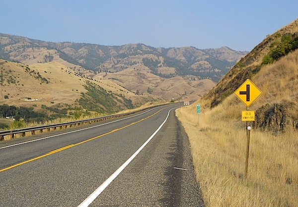
Coming from the south on US-95 your best plan is to watch the green vertical mile marker posts, and look for 222 (shown in the photo above). Turn left onto Old Hwy-95 and keep going until you see the bridge over the Salmon River. The campsite is just before the bridge, on the left. A very sharp (180°) left turn.
Coming from the south you will also see this sign before the turn-off.